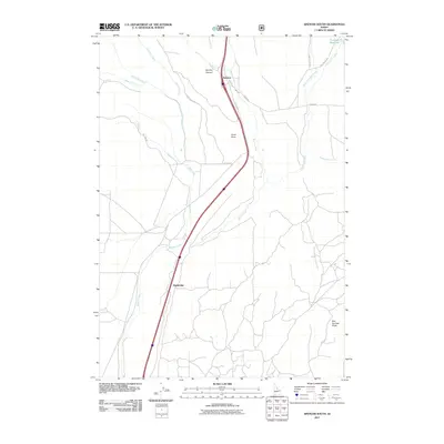
2011 Map of Spencer South
USGS Topo · Published 2011About this map
Spencer serves as the primary hub in this portion of Clark County, situated at the head of a drainage network that defines the local geography. The landscape is characterized by its complex hydrology, featuring the convergence of Beaver Creek and the multiple branches of the Dry Creek system, including East Dry Creek, Middle Dry Creek, and West Dry Creek. This 2011 survey documents the established transportation corridors that have long connected this high-desert region, such as Old Hwy 91 and the more remote Sky Line Rd. Notable landmarks like China Point and Bed Springs Butte provide distinct vertical relief against the creek valleys, while the presence of Highbridge to the south and Threemile Reservoir to the northeast highlights the human infrastructure required to manage travel and water in this arid Idaho terrain.
Find a feature on this map
21 named features on this map. Tap any name to fly to it.
Don’t see what you’re looking for? This feature index may not catch every label — zoom into the map to look around manually.
Map Details
Editions of this 2011 Spencer South Map
This is the sole edition of this map. No revisions or reprints were ever made.
Other maps of this area

1955 · Dubois
USGS Topo · 1:250,000

1957 · Paul Reservoir
USGS Topo · 1:62,500

1958 · Dubois
USGS Topo · 1:250,000

1964 · Dubois NW
USGS Topo · 1:24,000

1964 · Lone Butte
USGS Topo · 1:24,000

1964 · Dubois NE
USGS Topo · 1:24,000

1972 · Spencer South
USGS Topo · 1:24,000

1972 · Spencer North
USGS Topo · 1:24,000
1972 · Lookout Point
USGS Topo · 1:24,000
1972 · Gardner Lake
USGS Topo · 1:24,000