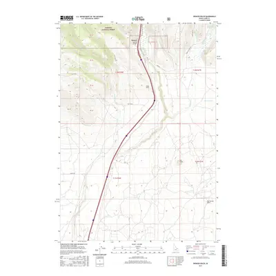
2017 Map of Spencer South
USGS Topo · Published 2017About this map
Spencer stands as the primary settlement on this Clark County landscape, positioned where the high desert meets the southern fringes of the Targhee National Forest. The geography is defined by a complex drainage system, including Middle Dry Cr, E Dry Cr, and Beaver Cr, which carve through the terrain as they flow southward from the mountains. This 2017 survey details a transition from forest highlands to volcanic-influenced plains, most notably evidenced by The Crater in the southeastern quadrant.
Find a feature on this map
31 named features on this map. Tap any name to fly to it.
Don’t see what you’re looking for? This feature index may not catch every label — zoom into the map to look around manually.
Map Details
Editions of this 2017 Spencer South Map
This is the sole edition of this map. No revisions or reprints were ever made.
Other maps of this area

1955 · Dubois
USGS Topo · 1:250,000

1957 · Paul Reservoir
USGS Topo · 1:62,500

1958 · Dubois
USGS Topo · 1:250,000

1964 · Dubois NW
USGS Topo · 1:24,000

1964 · Lone Butte
USGS Topo · 1:24,000

1964 · Dubois NE
USGS Topo · 1:24,000

1972 · Spencer South
USGS Topo · 1:24,000

1972 · Spencer North
USGS Topo · 1:24,000
1972 · Lookout Point
USGS Topo · 1:24,000
1972 · Gardner Lake
USGS Topo · 1:24,000