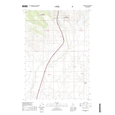
2020 Map of Spencer South
USGS Topo · Published 2020About this map
Spencer lies at the heart of this high-altitude landscape in Clark County, positioned where the drainage of Beaver Cr cuts through the foothills of the Targhee National Forest. The map documents a classic Western transportation corridor, with Interstate 15 and Old Hwy 91 tracing the natural path carved by the canyon. To the north and west, the terrain rises into the forest lands, marked by the deep incisions of Huntley Canyon and several branches of Dry Creek.
Find a feature on this map
34 named features on this map. Tap any name to fly to it.
Don’t see what you’re looking for? This feature index may not catch every label — zoom into the map to look around manually.
Map Details
Editions of this 2020 Spencer South Map
This is the sole edition of this map. No revisions or reprints were ever made.
Other maps of this area

1955 · Dubois
USGS Topo · 1:250,000

1957 · Paul Reservoir
USGS Topo · 1:62,500

1958 · Dubois
USGS Topo · 1:250,000

1964 · Dubois NW
USGS Topo · 1:24,000

1964 · Lone Butte
USGS Topo · 1:24,000

1964 · Dubois NE
USGS Topo · 1:24,000

1972 · Spencer South
USGS Topo · 1:24,000

1972 · Spencer North
USGS Topo · 1:24,000
1972 · Lookout Point
USGS Topo · 1:24,000
1972 · Gardner Lake
USGS Topo · 1:24,000