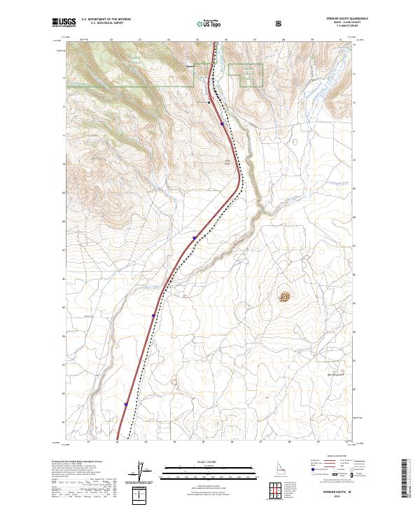
2023 Map of Spencer South
USGS Topo · Published 2023About this map
Spencer stands as the primary settlement in this high-desert landscape of Clark County, where the infrastructure of transportation meets the edges of the Targhee National Forest. The map documents a corridor of transit, dominated by the interstate and the historical path of Old Hwy 91, as they parallel Beaver Creek through the valley. This region is defined by its drainage patterns and volcanic geology, evidenced by features such as The Crater and Bed Springs Butte.
Find a feature on this map
26 named features on this map. Tap any name to fly to it.
Don’t see what you’re looking for? This feature index may not catch every label — zoom into the map to look around manually.
Map Details
Editions of this 2023 Spencer South Map
This is the sole edition of this map. No revisions or reprints were ever made.
Other maps of this area

1955 · Dubois
USGS Topo · 1:250,000

1957 · Paul Reservoir
USGS Topo · 1:62,500

1958 · Dubois
USGS Topo · 1:250,000

1964 · Dubois NW
USGS Topo · 1:24,000

1964 · Lone Butte
USGS Topo · 1:24,000

1964 · Dubois NE
USGS Topo · 1:24,000

1972 · Spencer South
USGS Topo · 1:24,000

1972 · Spencer North
USGS Topo · 1:24,000
1972 · Lookout Point
USGS Topo · 1:24,000
1972 · Gardner Lake
USGS Topo · 1:24,000