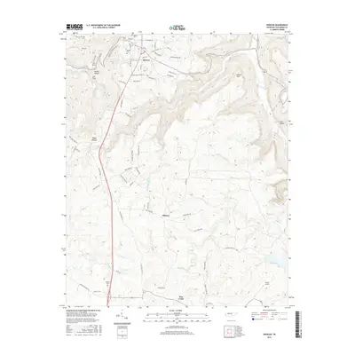
2016 Map of Spencer
USGS Topo · Published 2016About this map
Spencer serves as the focal point of this 2016 survey, where the town's street grid is clearly defined by historical thoroughfares like Old McMinnville St, Old Dunlap St, and Industry Dr. The landscape is defined by the sharp transition between the developed plateau and the deep dissections of the Highland Rim, visible in features such as Lost Cove, Molloy Hollow, and the steep walls of Cave Hollow. Genealogists will find significant value in the distribution of family-named cemeteries, including Spencer Cem, Denney Cem, and Hale Cem, which are tucked into the hillsides and hollows surrounding the settlement. To the southeast, the terrain gives way to the drainage of Piney Cr and the waters of Fall Cr Falls Lake, where the dramatic Piney Falls marks the rugged descent of the local waterways.
Find a feature on this map
79 named features on this map. Tap any name to fly to it.
Don’t see what you’re looking for? This feature index may not catch every label — zoom into the map to look around manually.
Map Details
Editions of this 2016 Spencer Map
This is the sole edition of this map. No revisions or reprints were ever made.
Other maps of this area

1892 · Pikeville
USGS Topo · 1:125,000

1893 · Mc Minnville
USGS Topo · 1:125,000

1895 · Mc Minnville
USGS Topo · 1:125,000

1895 · Pikeville
USGS Topo · 1:125,000

1935 · Brockdell
USGS Topo · 1:24,000

1935 · Smart Mountain
USGS Topo · 1:24,000

1943 · Cookeville
USGS Topo · 1:100,000

1944 · Cookeville
USGS Topo · 1:100,000
1946 · Smartt Mountain
USGS Topo · 1:24,000
1946 · Brockdell
USGS Topo · 1:24,000