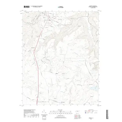
2019 Map of Spencer
USGS Topo · Published 2019About this map
Spencer serves as the focal point of this Van Buren County survey, positioned near the headwaters of the regional drainage network. The landscape is deeply incised by watercourses like Cane Creek and the Dry Fork, creating a series of dramatic points and hollows such as Haston Point and Lost Cove. This topography has historically dictated the settlement patterns, with communities like Pine Grove and Phiferes situated along the flatter ridges between the creek valleys.
Find a feature on this map
87 named features on this map. Tap any name to fly to it.
Don’t see what you’re looking for? This feature index may not catch every label — zoom into the map to look around manually.
Map Details
Editions of this 2019 Spencer Map
This is the sole edition of this map. No revisions or reprints were ever made.
Other maps of this area

1892 · Pikeville
USGS Topo · 1:125,000

1893 · Mc Minnville
USGS Topo · 1:125,000

1895 · Mc Minnville
USGS Topo · 1:125,000

1895 · Pikeville
USGS Topo · 1:125,000

1935 · Brockdell
USGS Topo · 1:24,000

1935 · Smart Mountain
USGS Topo · 1:24,000

1943 · Cookeville
USGS Topo · 1:100,000

1944 · Cookeville
USGS Topo · 1:100,000
1946 · Smartt Mountain
USGS Topo · 1:24,000
1946 · Brockdell
USGS Topo · 1:24,000