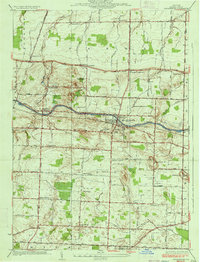
1934 Map of Spencerport
USGS Topo · Published 1934About this map
Spencerport serves as a central hub in this mid-1930s landscape, where the transport corridor of the Barge Canal and the New York Central Railroad dictates the local geography. The map reveals an area transitioning from purely rural agriculture to a more complex regional economy, evidenced by the presence of the Spencerport Waterworks and a dedicated Sewage Disposal Plant. Further south, the Chesbro Seminary stands near Ogden Center, reflecting the region's educational and institutional foundations.
Find a feature on this map
63 named features on this map. Tap any name to fly to it.
Don’t see what you’re looking for? This feature index may not catch every label — zoom into the map to look around manually.
Map Details
Editions of this 1934 Spencerport Map
2 editions found

Other maps of this area

1895 · Rochester
USGS Topo · 1:62,500

1895 · Ontario Beach
USGS Topo · 1:62,500

1898 · Rochester
USGS Topo · 1:62,500

1899 · Hamlin
USGS Topo · 1:62,500

1899 · Ontario Beach
USGS Topo · 1:62,500

1899 · Brockport
USGS Topo · 1:62,500

1912 · Rochester
USGS Topo · 1:62,500

1912 · Ontario Beach
USGS Topo · 1:62,500

1920 · Rochester
USGS Topo · 1:62,500

1931 · Rochester West
USGS Topo · 1:24,000