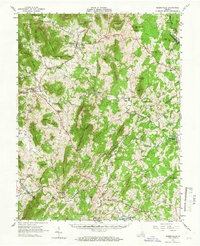
1961 Map of Sperryville
USGS Topo · Published 1966About this map
Shenandoah National Park dominates the northwestern corner of this mid-century survey, where the Devils Stairs and Jenkins Mountain rise above the headwaters of the Thornton River. The landscape transitions from the protected wilderness of the Blue Ridge into the agricultural valleys of Rappahannock and Culpeper counties. Settlements like Washington and Sperryville serve as central hubs for a network of rural communities, including Woodville, Boston, and Massies Corner.
Find a feature on this map
114 named features on this map. Tap any name to fly to it.
Don’t see what you’re looking for? This feature index may not catch every label — zoom into the map to look around manually.
Map Details
Editions of this 1961 Sperryville Map
2 editions found

Other maps of this area

1887 · Spottsylvania
USGS Topo · 1:125,000

1892 · Spottsylvania
USGS Topo · 1:125,000

1892 · Gordonsville
USGS Topo · 1:125,000

1893 · Luray
USGS Topo · 1:125,000

1894 · Warrenton
USGS Topo · 1:125,000

1894 · Warrenton
USGS Topo · 1:62,500

1905 · Luray
USGS Topo · 1:125,000

1927 · Remington
USGS Topo · 1:48,000

1929 · Stony Man
USGS Topo · 1:48,000

1930 · Warrenton
USGS Topo · 1:62,500