
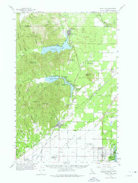
1961 Map of Spirit Lake
USGS Topo · Published 1963About this map
Spirit Lake and the expansive Rathdrum Prairie dominate this early 1960s landscape, illustrating a period of recreational growth alongside established rail infrastructure. The southern portion of the map is defined by the extensive grid of the Rathdrum Prairie, where the Coeur d'Alene Air Terminal sits near several small settlements like Haycrop and Garwood. This region shows the intricate network of the Milwaukee Road, Northern Pacific, and Spokane International railroads as they converge near Rathdrum.
Find a feature on this map
88 named features on this map. Tap any name to fly to it.
Don’t see what you’re looking for? This feature index may not catch every label — zoom into the map to look around manually.
Map Details
Editions of this 1961 Spirit Lake Map
2 editions found
Other maps of this area

1901 · Sandpoint
USGS Topo · 1:125,000

1901 · Spokane
USGS Topo · 1:125,000

1903 · Rathdrum
USGS Topo · 1:125,000

1911 · Priest Lake
USGS Topo · 1:250,000

1911 · Sandpoint
USGS Topo · 1:125,000

1913 · Priest Lake
USGS Topo · 1:250,000

1936 · Newport
USGS Topo · 1:96,000

1942 · Newport
USGS Topo · 1:125,000

1943 · Mt Spokane
USGS Topo · 1:62,500

1949 · Greenacres
USGS Topo · 1:62,500