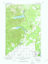
1961 Map of Spirit Lake
USGS Topo · Published 1975About this map
Rathdrum Prairie anchors the eastern half of this survey, revealing a landscape defined by its glacial heritage and early 1960s development. The transition from the high peaks of Rathdrum Mtn to the level plains is marked by a complex network of railways, including the Spokane International Railroad and the Northern Pacific. These tracks bisect the region, connecting old lakeside settlements and agricultural hubs like Rathdrum and Garwood.
Find a feature on this map
93 named features on this map. Tap any name to fly to it.
Don’t see what you’re looking for? This feature index may not catch every label — zoom into the map to look around manually.
Map Details
Editions of this 1961 Spirit Lake Map
2 editions found
Other maps of this area

1901 · Sandpoint
USGS Topo · 1:125,000

1901 · Spokane
USGS Topo · 1:125,000

1903 · Rathdrum
USGS Topo · 1:125,000

1911 · Priest Lake
USGS Topo · 1:250,000

1911 · Sandpoint
USGS Topo · 1:125,000

1913 · Priest Lake
USGS Topo · 1:250,000

1936 · Newport
USGS Topo · 1:96,000

1942 · Newport
USGS Topo · 1:125,000

1943 · Mt Spokane
USGS Topo · 1:62,500

1949 · Greenacres
USGS Topo · 1:62,500