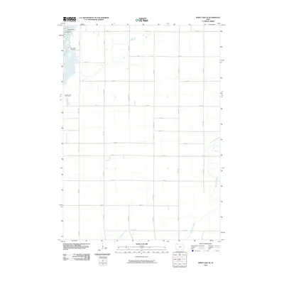
2010 Map of Spirit Lake SE
USGS Topo · Published 2010About this map
Arnolds Park anchors the northwestern corner of this landscape, serving as a gateway to the interconnected waters of the Iowa Great Lakes region. The survey documents the intricate shoreline and drainage patterns connecting East Okoboji Lake, Upper Gar Lake, Minnewashta Lake, and Lower Gar Lake. These bodies of water are central to the local geography, surrounded by a transition from residential developments like Orrs Campe Winakawin to the broad agricultural fields that dominate the southeastern sections. The rectilinear grid of the township system is clearly visible through thoroughfares such as Co Hwy M54 and various numbered avenues and streets. Further south, the terrain levels out where the headwaters of Big Muddy Creek and Little Muddy Creek meander through the prairie, illustrating the rural character of Dickinson County outside the immediate resort influence of the lakefront and the Woodlyn Hills Golf Course.
Find a feature on this map
30 named features on this map. Tap any name to fly to it.
Don’t see what you’re looking for? This feature index may not catch every label — zoom into the map to look around manually.
Map Details
Editions of this 2010 Spirit Lake SE Map
This is the sole edition of this map. No revisions or reprints were ever made.
Other maps of this area

1954 · Fairmont
USGS Topo · 1:250,000

1958 · Fairmont
USGS Topo · 1:250,000

1966 · Spencer
USGS Topo · 1:24,000

1966 · Dickens
USGS Topo · 1:24,000

1970 · Milford
USGS Topo · 1:24,000

1970 · Okoboji
USGS Topo · 1:24,000

1970 · Spirit Lake SE
USGS Topo · 1:24,000

1970 · Spirit Lake
USGS Topo · 1:24,000

1972 · Terril
USGS Topo · 1:24,000
1972 · Ruthven
USGS Topo · 1:24,000