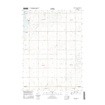
2015 Map of Spirit Lake SE
USGS Topo · Published 2015About this map
Arnolds Park and the northwestern edge of Milford anchor this topographic view of the Iowa Great Lakes region in the mid-2010s. The landscape is defined by the complex aquatic system of the Okoboji chain, including the southern reaches of East Okoboji Lake and the smaller basins of Upper Gar Lake, Minnewashta Lake, and Lower Gar Lake. This survey illustrates the transition from the developed lakeside communities into the surrounding agricultural lands of Dickinson and Clay counties. Drainage patterns in the eastern and southern sections are marked by Bull Ditch, Little Muddy Cr, and Big Muddy Cr, showing how the low-lying glacial topography was managed for cultivation. A rigid grid of section roads like 210th ST and Co HWY a48 segments the terrain, providing a clear reference for property boundaries and local infrastructure as they stood during this recent survey era.
Find a feature on this map
33 named features on this map. Tap any name to fly to it.
Don’t see what you’re looking for? This feature index may not catch every label — zoom into the map to look around manually.
Map Details
Editions of this 2015 Spirit Lake SE Map
This is the sole edition of this map. No revisions or reprints were ever made.
Other maps of this area

1954 · Fairmont
USGS Topo · 1:250,000

1958 · Fairmont
USGS Topo · 1:250,000

1966 · Spencer
USGS Topo · 1:24,000

1966 · Dickens
USGS Topo · 1:24,000

1970 · Milford
USGS Topo · 1:24,000

1970 · Okoboji
USGS Topo · 1:24,000

1970 · Spirit Lake SE
USGS Topo · 1:24,000

1970 · Spirit Lake
USGS Topo · 1:24,000

1972 · Terril
USGS Topo · 1:24,000
1972 · Ruthven
USGS Topo · 1:24,000