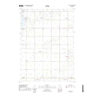
2018 Map of Spirit Lake SE
USGS Topo · Published 2018About this map
Milford and Arnolds Park anchor the northern portion of this landscape, representing a significant corridor of settlement near the Iowa Great Lakes region. The map reveals a transition from the structured residential blocks of Milford to the more open, agricultural terrain of the Dickinson and Clay county line. Water drainage patterns define the rural topography, with Big Muddy Cr and Little Muddy Cr winding through the southern townships while Bull Ditch manages water further north. Lakeside areas such as Gingles Point and Kruses Beach highlight the recreational character of the lake margins, contrasted with the extensive grid of secondary roads like Dirt Field Rd and Sunshine Run that serve the outlying farmsteads.
Find a feature on this map
33 named features on this map. Tap any name to fly to it.
Don’t see what you’re looking for? This feature index may not catch every label — zoom into the map to look around manually.
Map Details
Editions of this 2018 Spirit Lake SE Map
This is the sole edition of this map. No revisions or reprints were ever made.
Other maps of this area

1954 · Fairmont
USGS Topo · 1:250,000

1958 · Fairmont
USGS Topo · 1:250,000

1966 · Spencer
USGS Topo · 1:24,000

1966 · Dickens
USGS Topo · 1:24,000

1970 · Milford
USGS Topo · 1:24,000

1970 · Okoboji
USGS Topo · 1:24,000

1970 · Spirit Lake SE
USGS Topo · 1:24,000

1970 · Spirit Lake
USGS Topo · 1:24,000

1972 · Terril
USGS Topo · 1:24,000
1972 · Ruthven
USGS Topo · 1:24,000