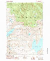
1984 Map of Spirit Lake West
USGS Topo · Published 1984About this map
Mount St Helens National Volcanic Monument defines the southern portion of this post-eruption landscape, documenting the dramatic changes following the 1980 volcanic event. The map provides a critical geographic record of the region, featuring the North Fork Toutle River Pre-Eruption Channel, an essential detail for understanding how the debris flow altered the local drainage. To the north, the terrain transitions into the Gifford Pinchot National Forest, where a network of lakes including Tradedollar Lake, Lonesome Lake, and Venus Lake remain scattered among peaks like Black Mountain. High-elevation landmarks such as Mount Margaret and Mount Whittier overlook the recently formed Coldwater Lake and the iconic Spirit Lake. The presence of several Borrow Pits and a Quarry near the Cowlitz and Skamania county line reflects the human activity and recovery efforts in this evolving wilderness.
Find a feature on this map
35 named features on this map. Tap any name to fly to it.
Don’t see what you’re looking for? This feature index may not catch every label — zoom into the map to look around manually.
Map Details
Editions of this 1984 Spirit Lake West Map
2 editions found
Other maps of this area

1919 · Mount St Helens
USGS Topo · 1:125,000

1953 · Hoquiam
USGS Topo · 1:250,000

1953 · Cougar
USGS Topo · 1:62,500

1953 · Elk Rock
USGS Topo · 1:62,500

1957 · Hoquiam
USGS Topo · 1:250,000

1957 · Spirit Lake
USGS Topo · 1:62,500

1958 · Mt St. Helens
USGS Topo · 1:62,500

1958 · Hoquiam
USGS Topo · 1:250,000

1962 · Hoquiam
USGS Topo · 1:250,000
1975 · Mt. St. Helens NE
USGS Topo · 1:24,000