
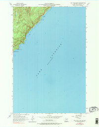
1956 Map of Split Rock Point NE
USGS Topo · Published 1958About this map
Split Rock Lighthouse stands as the primary landmark on this mid-century survey of the Lake County shoreline. The map documents the dramatic meeting of land and water where the township of Beaver Bay meets the vast expanse of Lake Superior. The coastal topography is defined by sharp indentations and small protective harbors, including Islet Bay, Pine Bay, and the interestingly named Little Two Harbors. Offshore, the survey notes hazards like Gull Rock, providing a detailed record of the navigable waters and the rugged North Shore landscape as it appeared in the 1950s. The dense contour lines along the coast reveal the significant elevation changes that necessitated the iconic lighthouse for maritime safety.
Find a feature on this map
7 named features on this map. Tap any name to fly to it.
Don’t see what you’re looking for? This feature index may not catch every label — zoom into the map to look around manually.
Map Details
Editions of this 1956 Split Rock Point NE Map
2 editions found
Other maps of this area

1954 · Silver Bay
USGS Topo · 1:62,500

1954 · Two Harbors
USGS Topo · 1:250,000

1956 · Split Rock Point
USGS Topo · 1:24,000

1956 · Finland
USGS Topo · 1:62,500

1956 · Illgen City
USGS Topo · 1:24,000

1956 · Split Rock Point
USGS Topo · 1:62,500

1957 · Two Harbors
USGS Topo · 1:250,000

1958 · Two Harbors
USGS Topo · 1:250,000

1964 · Two Harbors
USGS Topo · 1:250,000

1976 · Two Harbors
USGS Topo · 1:100,000