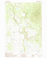
1988 Map of Spodue Mtn
USGS Topo · Published 1988About this map
The Sycan River meanders south through the heart of the high country, eventually feeding the broader Sprague River Valley at the bottom of the sheet. This late-twentieth-century landscape is defined by its water sources and forestry history, straddling the Forest Boundary between the Winema National Forest and Fremont National Forest. Notable for its many small-scale water features, the map records numerous family-named or descriptive points such as Tim Brown Spring, Chester Spring, and Wild Billy Lake. The presence of the Lookout Tower Black Hills overlooking the Black Hills and the Cinder Pit to the northeast suggests the area's ongoing focus on fire management and resource extraction. Land use is further evidenced by the Corrals located near the southern margin and the grassy expanse of Cordella Flat in the north.
Find a feature on this map
28 named features on this map. Tap any name to fly to it.
Don’t see what you’re looking for? This feature index may not catch every label — zoom into the map to look around manually.
Map Details
Editions of this 1988 Spodue Mtn Map
This is the sole edition of this map. No revisions or reprints were ever made.
Other maps of this area

1889 · Klamath
USGS Topo · 1:250,000

1894 · Klamath
USGS Topo · 1:250,000

1955 · Klamath Falls
USGS Topo · 1:250,000

1958 · Klamath Falls
USGS Topo · 1:250,000

1960 · Riverbed Butte
USGS Topo · 1:62,500

1960 · Bly
USGS Topo · 1:62,500

1960 · Beatty
USGS Topo · 1:62,500

1960 · Fuego Mountain
USGS Topo · 1:62,500

1980 · Williamson River
USGS Topo · 1:100,000
1988 · Riverbed Butte Spring
USGS Topo · 1:24,000