1955 Map of Spokane
USGS Topo · Published 1980About this map
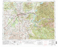
Spokane Valley serves as the central corridor for this 1955 survey, where the convergence of the Spokane River and multiple major rail lines including the Great Northern and Northern Pacific drove regional development. The landscape transitions from the urban centers of Spokane and Coeur d'Alene into the expansive timberlands of the Kaniksu National Forest and Coeur d'Alene National Forest.
Find a feature on this map
196 named features on this map. Tap any name to fly to it.
Don’t see what you’re looking for? This feature index may not catch every label — zoom into the map to look around manually.
Map Details
Editions of this 1955 Spokane Map
2 editions found

Other maps of this area

1901 · Sandpoint
USGS Topo · 1:125,000

1901 · Spokane
USGS Topo · 1:125,000

1901 · Coeur D'Alene District
USGS Topo · 1:62,500

1903 · Oakesdale
USGS Topo · 1:125,000

1903 · Rathdrum
USGS Topo · 1:125,000

1903 · Coeur D'Alene District
USGS Topo · 1:62,500

1905 · Oakesdale
USGS Topo · 1:125,000

1906 · Coeur D'Alene District
USGS Topo · 1:62,500

1909 · Cataldo
USGS Topo · 1:125,000

1910 · Pullman
USGS Topo · 1:125,000