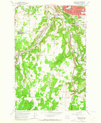
1963 Map of Spokane SW
USGS Topo · Published 1964About this map
The southern suburbs of Spokane and the rural transition into the Moran Prairie are documented in this early 1960s survey. The landscape is defined by the sharp descent into the Hangman Creek valley and the industrial corridor centered on Marshall, where several major rail lines converge, including the Seattle Portland and Spokane and the Northern Pacific. Residential expansion is evident in the residential clusters at Geiger Heights and along the city's Corporate Boundary, supported by new institutions like Sacajawea Jr High Sch and Our Lady of Fatima Sch. Outside the city limits, the terrain remains largely agricultural and open, dotted with local landmarks such as Glenora Ch and the Northwest Memorial Garden (Cemetery). This era of development is marked by the presence of numerous broadcasting sites, including Radio Towers (KNEW) and the Radio Tower (KPEG), signaling the region's growing communications infrastructure.
Find a feature on this map
39 named features on this map. Tap any name to fly to it.
Don’t see what you’re looking for? This feature index may not catch every label — zoom into the map to look around manually.
Map Details
Editions of this 1963 Spokane SW Map
This is the sole edition of this map. No revisions or reprints were ever made.
Other maps of this area

1901 · Spokane
USGS Topo · 1:125,000

1903 · Oakesdale
USGS Topo · 1:125,000

1905 · Oakesdale
USGS Topo · 1:125,000

1943 · Medical Lake
USGS Topo · 1:62,500

1950 · Spokane NE
USGS Topo · 1:24,000

1950 · Spokane SE
USGS Topo · 1:24,000

1950 · Spokane SW
USGS Topo · 1:24,000

1950 · Spokane NW
USGS Topo · 1:24,000

1950 · Spokane
USGS Topo · 1:62,500

1954 · Airway Heights
USGS Topo · 1:24,000