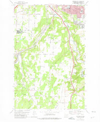
1973 Map of Spokane SW
USGS Topo · Published 1975About this map
Spokane extends its southern corporate boundary into a landscape defined by the deep incision of Hangman Creek and the surrounding plateau. This early 1970s survey captures the city's suburban growth as it meets established landmarks like the Manito Golf and Country Club and the residential area of Geiger Heights. The map highlights a significant historical transition with the presence of both the active Burlington Northern line and a section of Abandoned Burlington Northern trackage, illustrating the shifting rail economy of the Inland Northwest. Cultural sites such as Spokane Memorial Gardens (Cem) and the Mullan Military Road Historical Monument provide touchpoints for local historians, while family-named routes like Stentz Road and Smythe Road mark the rural character of the southern hills near Marshall.
Find a feature on this map
49 named features on this map. Tap any name to fly to it.
Don’t see what you’re looking for? This feature index may not catch every label — zoom into the map to look around manually.
Map Details
Editions of this 1973 Spokane SW Map
3 editions found
Other maps of this area

1901 · Spokane
USGS Topo · 1:125,000

1903 · Oakesdale
USGS Topo · 1:125,000

1905 · Oakesdale
USGS Topo · 1:125,000

1943 · Medical Lake
USGS Topo · 1:62,500

1950 · Spokane NE
USGS Topo · 1:24,000

1950 · Spokane SE
USGS Topo · 1:24,000

1950 · Spokane SW
USGS Topo · 1:24,000

1950 · Spokane NW
USGS Topo · 1:24,000

1950 · Spokane
USGS Topo · 1:62,500

1954 · Airway Heights
USGS Topo · 1:24,000