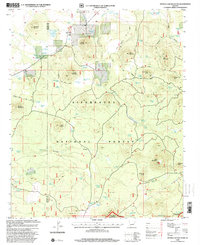
1998 Map of Sponseller Mountain
USGS Topo · Published 2001About this map
Sitgreaves National Forest dominates this Arizona landscape, which was revised by the USDA Forest Service in the late 1990s. The terrain is defined by a series of volcanic peaks and knolls, including Sponseller Mountain, Ziegler Mountain, and the curiously named Pulp Burn Knoll. Water management is central to the area's utility, evidenced by a dense network of tanks and springs such as Sponseller Lake, Penrod No 1 Tank, and Hog Spring.
Find a feature on this map
83 named features on this map. Tap any name to fly to it.
Don’t see what you’re looking for? This feature index may not catch every label — zoom into the map to look around manually.
Map Details
Editions of this 1998 Sponseller Mountain Map
This is the sole edition of this map. No revisions or reprints were ever made.
Other maps of this area

1886 · St Johns
USGS Topo · 1:250,000

1892 · St Johns
USGS Topo · 1:250,000

1954 · Saint Johns
USGS Topo · 1:250,000

1957 · Saint Johns
USGS Topo · 1:250,000

1958 · Saint Johns
USGS Topo · 1:250,000

1961 · McNary
USGS Topo · 1:62,500

1962 · Saint Johns
USGS Topo · 1:250,000

1968 · Boundary Butte
USGS Topo · 1:24,000
1969 · Horseshoe Cienega
USGS Topo · 1:24,000
1971 · Vernon
USGS Topo · 1:24,000