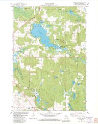
1982 Map of Spooner Lake
USGS Topo · Published 1982About this map
Spooner Lake dominates this northern Wisconsin landscape, serving as a central hub for the surrounding wetlands and waterways in 1982. The area is defined by its extensive public lands and research facilities, including the Spooner Lake State Public Fishery Area and the University of Wisconsin Experimental Farm near the Yellow River. In the southern reaches, the Beaver Brook State Public Hunting Grounds preserve the marshy terrain around Beaver Brook. Transport and infrastructure are represented by the Chicago and North Western rail line and the Nest of the Eagles Landing Strip. Genealogists and local historians will find value in the small settlement of Anah Springs and the nearby Anah Ch, along with numerous named water bodies like Little Spooner Lake and Dilly Lake that characterize this glacial topography.
Find a feature on this map
43 named features on this map. Tap any name to fly to it.
Don’t see what you’re looking for? This feature index may not catch every label — zoom into the map to look around manually.
Map Details
Editions of this 1982 Spooner Lake Map
This is the sole edition of this map. No revisions or reprints were ever made.
Other maps of this area

1948 · Spooner
USGS Topo · 1:48,000

1948 · Stone Lake
USGS Topo · 1:48,000

1949 · Spooner
USGS Topo · 1:48,000

1949 · Rice Lake
USGS Topo · 1:48,000

1950 · Stone Lake
USGS Topo · 1:48,000

1951 · Shell Lake
USGS Topo · 1:48,000

1951 · Rice Lake
USGS Topo · 1:48,000

1953 · Rice Lake
USGS Topo · 1:250,000

1959 · Rice Lake
USGS Topo · 1:250,000

1965 · Rice Lake
USGS Topo · 1:62,500