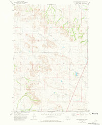
1981 Map of Sportsman Pond
USGS Topo · Published 1981About this map
Sportsman Pond serves as a central landmark in this high plains landscape of Fallon County, Montana. The terrain is defined by an intricate network of intermittent watercourses, most notably Lame Jones Creek and Milk Creek, which carve through the land before merging into larger drainages like Coon Creek. The drainage patterns here reveal the subtle topography of the Great Plains, where every minor rise and depression influences the flow of seasonal water toward Dry Creek.
Find a feature on this map
11 named features on this map. Tap any name to fly to it.
Don’t see what you’re looking for? This feature index may not catch every label — zoom into the map to look around manually.
Map Details
Editions of this 1981 Sportsman Pond Map
This is the sole edition of this map. No revisions or reprints were ever made.
Other maps of this area

1953 · Miles City
USGS Topo · 1:250,000

1957 · Miles City
USGS Topo · 1:250,000

1958 · Miles City
USGS Topo · 1:250,000

1981 · Baker
USGS Topo · 1:100,000

1981 · Baker
USGS Topo · 1:24,000

1981 · South Sandstone Reservoir
USGS Topo · 1:24,000

1981 · Willard
USGS Topo · 1:24,000
1981 · Willard SE
USGS Topo · 1:24,000

1981 · Little Pine Creek
USGS Topo · 1:24,000

1981 · Seven-Up Butte
USGS Topo · 1:24,000