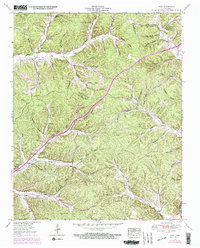
1952 Map of Spot
USGS Topo · Published 1970About this map
Spot serves as a small community hub in this mid-century portrait of Hickman County, where the landscape is defined by a dense network of hollows and creek drainage. The Duck River cuts through the southeastern corner, while the Sugar Creek and Tumbling Creek valleys dictate the settlement patterns and road placements. This survey, updated with 1968 aerial data, reveals a high concentration of family-named cemeteries and rural churches, including McMackins Cem, Sanders Cem, and Indian Creek Ch. The presence of the Pinewood Lookout Tower and the Salt Lick landmark suggest a landscape transitioning from traditional agriculture to managed timber and forest services. Dozens of named hollows, from Limekiln Hollow to Chalkbank Hollow, illustrate the deep local geography and provided the namesake for many of the area's earliest homesteads and small family farms.
Find a feature on this map
94 named features on this map. Tap any name to fly to it.
Don’t see what you’re looking for? This feature index may not catch every label — zoom into the map to look around manually.
Map Details
Editions of this 1952 Spot Map
3 editions found
Other maps of this area

1901 · Colombia
USGS Topo · 1:125,000

1936 · Gorman
USGS Topo · 1:24,000

1936 · Coble
USGS Topo · 1:24,000

1936 · Nunnelly
USGS Topo · 1:24,000

1936 · Whitfield
USGS Topo · 1:24,000

1936 · Bucksnort
USGS Topo · 1:24,000

1936 · Texas Hollow
USGS Topo · 1:24,000

1936 · Spot
USGS Topo · 1:24,000

1936 · Tennessee City
USGS Topo · 1:24,000

1936 · Dickson
USGS Topo · 1:24,000