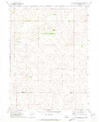
1971 Map of Spotted Horse Valley
USGS Topo · Published 1973About this map
Spotted Horse Valley defines this Sandhills landscape along the border of Arthur and Keith counties in the early 1970s. The region is characterized by a sparse network of remote cattle operations and small rural facilities, reflecting the late 20th-century ranching economy of western Nebraska. Notable landholdings include the Vasa Ranch, Dean Simpson Ranch, and Hiner Ranch, all clustered around the valley floor. Education in this isolated area was anchored by School No 55, which served the families of the Robert Simpson Ranch and Williams Ranch. The topography is meticulously detailed with fine red dashed lines indicating specific fence and field lines, providing researchers with a precise record of historical property boundaries and grazing patterns in a land of few prominent landmarks.
Find a feature on this map
8 named features on this map. Tap any name to fly to it.
Don’t see what you’re looking for? This feature index may not catch every label — zoom into the map to look around manually.
Map Details
Editions of this 1971 Spotted Horse Valley Map
This is the sole edition of this map. No revisions or reprints were ever made.
Other maps of this area

1897 · Ogallala
USGS Topo · 1:125,000

1898 · Paxton
USGS Topo · 1:125,000

1900 · Ogallala
USGS Topo · 1:125,000

1901 · Paxton
USGS Topo · 1:125,000

1949 · Arthur
USGS Topo · 1:62,500

1949 · Flats
USGS Topo · 1:62,500

1950 · Flats
USGS Topo · 1:62,500

1950 · Arthur
USGS Topo · 1:62,500

1954 · North Platte
USGS Topo · 1:250,000

1956 · North Platte
USGS Topo · 1:250,000