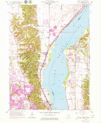
1949 Map of Spring Bay
USGS Topo · Published 1979About this map
Peoria Lake and the Upper Illinois River dominate this landscape at a time when the mid-century expansion of Peoria was beginning to climb the western bluffs. The river serves as a county divide, with the established community of Spring Bay on the eastern shore and the industrial and residential growth of Richwoods and Peoria Heights to the west. This survey illustrates the intricate terrain of the western riverbank, where narrow valleys like Moon Hollow and Strawberry Hollow cut through the high ground before meeting the river flats.
Find a feature on this map
49 named features on this map. Tap any name to fly to it.
Don’t see what you’re looking for? This feature index may not catch every label — zoom into the map to look around manually.
Map Details
Editions of this 1949 Spring Bay Map
This is the sole edition of this map. No revisions or reprints were ever made.
Other maps of this area

1893 · Metamora
USGS Topo · 1:62,500

1893 · Dunlap
USGS Topo · 1:62,500

1898 · Dunlap
USGS Topo · 1:62,500

1905 · Peoria
USGS Topo · 1:62,500

1927 · Peoria
USGS Topo · 1:62,500

1928 · Mackinaw
USGS Topo · 1:62,500

1932 · Mackinaw
USGS Topo · 1:62,500

1932 · Dunlap
USGS Topo · 1:62,500

1933 · Dunlap
USGS Topo · 1:62,500

1937 · Metamora
USGS Topo · 1:62,500