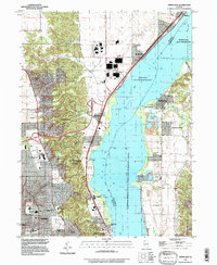
1996 Map of Spring Bay
USGS Topo · Published 1997About this map
Upper Peoria Lake dominates this mid-1990s landscape, serving as a focal point for the surrounding riverfront communities in Woodford and Peoria Counties. On the western shore, the industrial and residential growth of Mossville and Peoria is evident, while the eastern bank maintains a different character with the Bayview Gardens settlement and the Illinois River State Fish and Wildlife Area. The terrain is marked by numerous wooded ravines, such as Strawberry Hollow and Poppet Hollow, which cut through the bluffs overlooking the Illinois River.
Find a feature on this map
61 named features on this map. Tap any name to fly to it.
Don’t see what you’re looking for? This feature index may not catch every label — zoom into the map to look around manually.
Map Details
Editions of this 1996 Spring Bay Map
This is the sole edition of this map. No revisions or reprints were ever made.
Other maps of this area

1893 · Metamora
USGS Topo · 1:62,500

1893 · Dunlap
USGS Topo · 1:62,500

1898 · Dunlap
USGS Topo · 1:62,500

1905 · Peoria
USGS Topo · 1:62,500

1927 · Peoria
USGS Topo · 1:62,500

1928 · Mackinaw
USGS Topo · 1:62,500

1932 · Mackinaw
USGS Topo · 1:62,500

1932 · Dunlap
USGS Topo · 1:62,500

1933 · Dunlap
USGS Topo · 1:62,500

1937 · Metamora
USGS Topo · 1:62,500