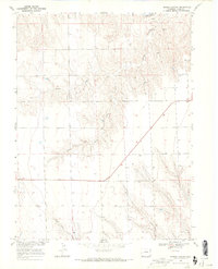
1968 Map of Spring Canyon
USGS Topo · Published 1971About this map
The Arikaree R cuts through this corner of Yuma County, defining a landscape marked by the complex drainage systems of Spring Canyon and the North Fork South Fork North Sand Creek. Surveyed in the late 1960s as part of the Department of the Interior’s program for the Missouri River Basin, the topography reflects a sparsely settled ranching region. Isolated homesteads and landmarks like Sharp Ranch and Winfield are connected by a network of unimproved roads and the prominent path of Highway 36. The map captures the agricultural footprint of the era, where dozens of scattered wells support the local water needs across the expansive high plains terrain.
Find a feature on this map
10 named features on this map. Tap any name to fly to it.
Don’t see what you’re looking for? This feature index may not catch every label — zoom into the map to look around manually.
Map Details
Editions of this 1968 Spring Canyon Map
2 editions found
Other maps of this area

1954 · Limon
USGS Topo · 1:250,000

1957 · Limon
USGS Topo · 1:250,000

1958 · Limon
USGS Topo · 1:250,000

1963 · Wildcat Canyon
USGS Topo · 1:24,000

1968 · Abarr SE
USGS Topo · 1:24,000

1968 · Vernon SW
USGS Topo · 1:24,000

1968 · Spring Canyon
USGS Topo · 1:24,000

1968 · Adler Creek
USGS Topo · 1:24,000

1968 · Idalia
USGS Topo · 1:24,000

1969 · Idalia SE
USGS Topo · 1:24,000