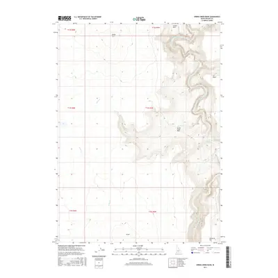
2017 Map of Spring Creek Basin
USGS Topo · Published 2017About this map
Spring Creek Basin characterizes this arid portion of Owyhee County, where the high desert landscape is deeply incised by the drainage systems of the Owyhee River. The winding course of the South Fork Owyhee River carves through the northeastern corner of the map, while the Little Owyhee River passes through the southeastern section, illustrating the complex hydrology of this remote sagebrush steppe. The terrain is marked by significant landmarks like Spring Butte and the elevation at 45 Hill, which provide vantage points over the surrounding Y P Desert. This 2017 survey details a landscape defined by seasonal watercourses such as Spring Cr and the broad, open stretches of Halogeton Flat and Juniper Basin, capturing the area's transition between volcanic uplands and river canyons.
Find a feature on this map
15 named features on this map. Tap any name to fly to it.
Don’t see what you’re looking for? This feature index may not catch every label — zoom into the map to look around manually.
Map Details
Editions of this 2017 Spring Creek Basin Map
This is the sole edition of this map. No revisions or reprints were ever made.
Other maps of this area

1955 · Jordan Valley
USGS Topo · 1:250,000

1957 · Jordan Valley
USGS Topo · 1:250,000

1958 · Jordan Valley
USGS Topo · 1:250,000

1973 · Coyote Hole
USGS Topo · 1:24,000

1973 · Red Basin
USGS Topo · 1:24,000

1973 · Grassy Ridge
USGS Topo · 1:24,000

1973 · Spring Creek Basin
USGS Topo · 1:24,000
1973 · Star Valley
USGS Topo · 1:24,000
1977 · Bull Basin Camp
USGS Topo · 1:24,000
1982 · Star Valley Knoll
USGS Topo · 1:24,000