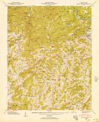
1946 Map of Spring Creek
USGS Topo · Published 1957About this map
Pisgah National Forest encompasses the vast majority of this landscape, where the topography of the Blue Ridge Mountains dictated the slow development of western North Carolina. Life in the 1940s was concentrated along the narrow bottomlands of Spring Creek, Big Pine Creek, and the French Broad River, where small communities like Trust and Luck served as local hubs. The presence of numerous family cemeteries and neighborhood institutions—such as Doe Branch Sch, Upper Little Pine Sch, and Primitive Ch—indicates a deeply rooted mountain culture.
Find a feature on this map
149 named features on this map. Tap any name to fly to it.
Don’t see what you’re looking for? This feature index may not catch every label — zoom into the map to look around manually.
Map Details
Editions of this 1946 Spring Creek Map
3 editions found
Other maps of this area

1894 · Asheville
USGS Topo · 1:125,000

1901 · Asheville
USGS Topo · 1:125,000

1935 · Paint Rock
USGS Topo · 1:24,000

1935 · Hot Springs
USGS Topo · 1:24,000

1935 · Spring Creek
USGS Topo · 1:24,000

1935 · Lemon Gap
USGS Topo · 1:24,000

1936 · Marshall
USGS Topo · 1:24,000

1936 · Sandymush
USGS Topo · 1:24,000

1936 · White Rock
USGS Topo · 1:24,000

1936 · Hepco
USGS Topo · 1:24,000