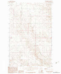
1983 Map of Spring Creek SW
USGS Topo · Published 1983About this map
Tomato Can Creek meanders through the central landscape of this 1983 provisional survey, illustrating the seasonal drainage patterns of the eastern Montana plains. The terrain is defined by the sharp transition between the upland plateaus and the intricate coulees that feed into Spring Creek along the eastern margin. These intermittent watercourses and the sparse trail network reflect the ranching character of the Fort Peck Indian Reservation, where the land is primarily organized by the rectangular survey system of Township 30 North, Township 29 North and Range 42 East, Range 43 East. Sargent Creek appears in the southwest, further defining the watershed of this open, rural territory.
Find a feature on this map
5 named features on this map. Tap any name to fly to it.
Don’t see what you’re looking for? This feature index may not catch every label — zoom into the map to look around manually.
Map Details
Editions of this 1983 Spring Creek SW Map
This is the sole edition of this map. No revisions or reprints were ever made.
Other maps of this area

1914 · Nashua
USGS Topo · 1:62,500

1915 · Frazer
USGS Topo · 1:62,500

1915 · Spring Creek
USGS Topo · 1:62,500

1916 · Nashua
USGS Topo · 1:62,500

1918 · Porcupine Valley
USGS Topo · 1:62,500

1954 · Glasgow
USGS Topo · 1:250,000

1957 · Glasgow
USGS Topo · 1:250,000

1958 · Glasgow
USGS Topo · 1:250,000
1972 · Dubbe Reservoir
USGS Topo · 1:24,000
1972 · Milk River Coulee
USGS Topo · 1:24,000