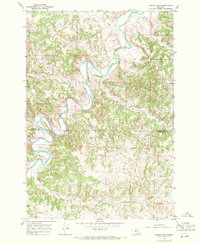
1967 Map of Spring Gulch
USGS Topo · Published 1971About this map
The Tongue River meanders through the heart of this landscape, its path defining the rugged transition between the high plateaus and the valley floor. In the late 1960s, human activity in this corner of the Montana ranchlands is marked by a network of water management and transit, including the prominent Flying V Ditch and several miles of Jeep Trail cutting across the upland breaks. The boundary between Rosebud and Big Horn Counties bisects the southern portion of the quadrangle, where the terrain is heavily dissected by drainages like Post Creek and Anderson Creek. Scattered throughout are numerous water sources simply marked as Spring or Springs, critical lifelines for the livestock and wildlife that populate these gulches. From Dutch Hollow in the north to the southern reaches of Coal Creek, the map captures a rural environment focused on the essential hydrology of the American West.
Find a feature on this map
15 named features on this map. Tap any name to fly to it.
Don’t see what you’re looking for? This feature index may not catch every label — zoom into the map to look around manually.
Map Details
Editions of this 1967 Spring Gulch Map
This is the sole edition of this map. No revisions or reprints were ever made.
Other maps of this area

1954 · Hardin
USGS Topo · 1:250,000

1957 · Hardin
USGS Topo · 1:250,000

1958 · Hardin
USGS Topo · 1:250,000

1967 · Holmes Ranch
USGS Topo · 1:24,000

1967 · Birney
USGS Topo · 1:24,000

1967 · Tongue River Dam
USGS Topo · 1:24,000

1967 · Lacey Gulch
USGS Topo · 1:24,000
1967 · Pine Butte School
USGS Topo · 1:24,000
1967 · Taintor Desert
USGS Topo · 1:24,000
1967 · Birney SW
USGS Topo · 1:24,000