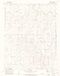
1972 Map of Spring
USGS Topo · Published 1975About this map
The Old Indian Treaty Boundary carves a straight horizontal line across this Kansas landscape, marking a significant historical division just south of the settlement at Spring. In the early 1970s, this region of Harper County was defined by its intersecting transportation and utility infrastructure, where the Missouri Pacific Railroad and the Atchison Topeka and Santa Fe lines crossed the drainages of Beaver Creek and Bluff Creek. Small rural landmarks such as Hopewell Ch and Burchfiel Ch anchor the surrounding farmstead grid. Industrial activity is concentrated in the north along the creek, where a Sandpit and Powerplant are located. The map also captures the transition from Kansas into Oklahoma's Alfalfa and Grant Counties along the southern margin.
Find a feature on this map
20 named features on this map. Tap any name to fly to it.
Don’t see what you’re looking for? This feature index may not catch every label — zoom into the map to look around manually.
Map Details
Editions of this 1972 Spring Map
This is the sole edition of this map. No revisions or reprints were ever made.
Other maps of this area

1889 · Anthony
USGS Topo · 1:125,000

1889 · Caldwell
USGS Topo · 1:125,000

1891 · Anthony
USGS Topo · 1:125,000

1893 · Caldwell
USGS Topo · 1:125,000

1897 · Caldwell
USGS Topo · 1:125,000

1955 · Wichita
USGS Topo · 1:250,000

1955 · Enid
USGS Topo · 1:250,000

1955 · Woodward
USGS Topo · 1:250,000

1955 · Pratt
USGS Topo · 1:250,000

1958 · Enid
USGS Topo · 1:250,000