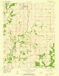
1957 Map of Spring Hill
USGS Topo · Published 1958About this map
Spring Hill sits at the intersection of rural townships along the border of Johnson and Miami Counties, anchoring a landscape shaped by mid-century agriculture and rail transport. The St Louis San Francisco railroad cuts a diagonal path through the terrain, passing through Hillsdale and near the headwaters of Little Bull Creek. To the east, the Missouri Pacific line serves the small communities of Wagstaff and Chiles, reflecting the region's reliance on these iron arteries for moving goods and people during the 1950s.
Find a feature on this map
27 named features on this map. Tap any name to fly to it.
Don’t see what you’re looking for? This feature index may not catch every label — zoom into the map to look around manually.
Map Details
Editions of this 1957 Spring Hill Map
2 editions found
Other maps of this area

1887 · Olathe
USGS Topo · 1:125,000

1893 · Olathe
USGS Topo · 1:125,000

1947 · Lawrence
USGS Topo · 1:250,000

1950 · Lawrence
USGS Topo · 1:250,000

1956 · Stilwell
USGS Topo · 1:24,000

1956 · Bucyrus
USGS Topo · 1:24,000
1956 · Ocheltree
USGS Topo · 1:24,000

1956 · Paola East
USGS Topo · 1:24,000

1956 · Lawrence
USGS Topo · 1:250,000
1957 · Paola West
USGS Topo · 1:24,000