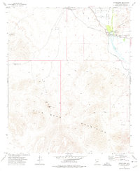
1973 Map of Spring Mtn.
USGS Topo · Published 1976About this map
The Gila River cuts through this arid landscape, serving as the lifeblood for an extensive irrigation network that includes the Arlington Canal, Enterprise Canal, and Eighty Bend Canal. At the center of this hydraulic system is Gillespie Dam, accompanied by a Gaging Station and several quarries. This infrastructure illustrates the mid-century effort to divert water for agriculture and industry in the harsh terrain between the Buckeye Hills and the Gila Bend Mountains.
Find a feature on this map
21 named features on this map. Tap any name to fly to it.
Don’t see what you’re looking for? This feature index may not catch every label — zoom into the map to look around manually.
Map Details
Editions of this 1973 Spring Mtn. Map
2 editions found
Other maps of this area

1951 · Cotton Center
USGS Topo · 1:62,500

1951 · Woolsey Peak
USGS Topo · 1:62,500

1954 · Phoenix
USGS Topo · 1:250,000

1957 · Phoenix
USGS Topo · 1:250,000

1958 · Phoenix
USGS Topo · 1:250,000

1958 · Hassayampa
USGS Topo · 1:24,000

1958 · Buckeye
USGS Topo · 1:62,500

1960 · Phoenix
USGS Topo · 1:250,000

1962 · Arlington
USGS Topo · 1:62,500

1969 · Phoenix
USGS Topo · 1:250,000