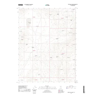
2018 Map of Spring Valley Summit
USGS Topo · Published 2018About this map
Spring Valley and the surrounding high-desert ranges of Eureka County are documented here in detail, showcasing a landscape defined by isolated water sources and significant vertical relief. The terrain is structured around the Fish Creek Range and the Mountain Boy Range, where numerous peaks such as Atrypa Peak and Grays Peak rise above the arid floor. The distribution of water is critical in this environment, marked by sites like McCulloughs Spring, Josephine Spring, and the seasonally variable Stevens Basin Dry Lake. These features reflect the long-standing importance of reliable water points for ranching and transit in central Nevada. High-elevation landmarks including Spring Valley Summit and Pinnacle Peak provide clear reference points across the township and range grid, while canyons like Robinson Canyon and Cave Canyon cut through the limestone and volcanic formations that characterize this segment of the Great Basin.
Find a feature on this map
37 named features on this map. Tap any name to fly to it.
Don’t see what you’re looking for? This feature index may not catch every label — zoom into the map to look around manually.
Map Details
Editions of this 2018 Spring Valley Summit Map
This is the sole edition of this map. No revisions or reprints were ever made.
Other maps of this area
1926 · Roberts Mountains
USGS Topo · 1:250,000
1929 · Roberts Mountains
USGS Topo · 1:250,000
1953 · Pinto Summit
USGS Topo · 1:62,500
1953 · Eureka
USGS Topo · 1:62,500

1955 · Millett
USGS Topo · 1:250,000
1956 · Bellevue Peak
USGS Topo · 1:62,500
1956 · Whistler Mtn
USGS Topo · 1:62,500

1956 · Ely
USGS Topo · 1:250,000

1959 · Ely
USGS Topo · 1:250,000

1959 · Millett
USGS Topo · 1:250,000