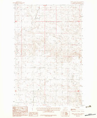
1983 Map of Spring Valley West
USGS Topo · Published 1983About this map
The settlement of Kolstad sits at the center of this 1983 topographic study, surrounded by the high-plains terrain of Valley County. This landscape is defined by the drainage systems of East Fork Porcupine Creek in the north and Tomato Can Creek to the south. The terrain is notably marked by the Hankie Hills and the broad expanse of Spring Valley, which together illustrate the intricate erosion patterns and coulees characteristic of this portion of the Fort Peck Indian Reservation.
Find a feature on this map
9 named features on this map. Tap any name to fly to it.
Don’t see what you’re looking for? This feature index may not catch every label — zoom into the map to look around manually.
Map Details
Editions of this 1983 Spring Valley West Map
This is the sole edition of this map. No revisions or reprints were ever made.
Other maps of this area

1915 · Spring Creek
USGS Topo · 1:62,500

1918 · Porcupine Valley
USGS Topo · 1:62,500

1954 · Glasgow
USGS Topo · 1:250,000

1957 · Glasgow
USGS Topo · 1:250,000

1958 · Glasgow
USGS Topo · 1:250,000

1973 · Baylor SE
USGS Topo · 1:24,000

1973 · Larslan
USGS Topo · 1:24,000
1973 · Blink Springs
USGS Topo · 1:24,000
1983 · Spring Valley East
USGS Topo · 1:24,000
1983 · Spring Creek SW
USGS Topo · 1:24,000