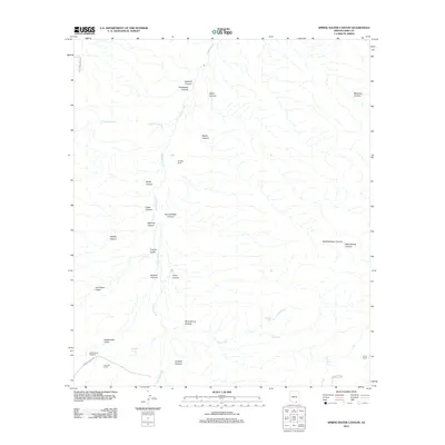
2012 Map of Spring Water Canyon
USGS Topo · Published 2012About this map
Cienega Creek serves as the primary drainage axis through this desert landscape, where a network of deeply etched canyons and gulches converge. Named ranching sites like Cienega Ranch, Hummel Ranch, and Clyne Ranch indicate the sparse but established cattle-rearing history of this Pima County region. The topography is defined by the intersection of numerous landforms such as Spring Water Canyon, Gardner Canyon, and Shellenberger Canyon, which feed into the larger creek system. Water management is a visible priority for these remote holdings, evidenced by the presence of Cottonwood Windmill, Oil Well Tank, and Wind Tank. The map also reveals older transportation routes like S Wagon Rim Rd, which traverses the southern portion of the quadrangle near Mud Spring. This survey provides a clear view of the ranching infrastructure and hydrological features that sustain life in this arid canyon country.
Find a feature on this map
33 named features on this map. Tap any name to fly to it.
Don’t see what you’re looking for? This feature index may not catch every label — zoom into the map to look around manually.
Map Details
Editions of this 2012 Spring Water Canyon Map
This is the sole edition of this map. No revisions or reprints were ever made.
Other maps of this area
1904 · Patagonia
USGS Topo · 1:125,000
1905 · Patagonia
USGS Topo · 1:125,000
1915 · Benson
USGS Topo · 1:125,000
1926 · Whetstone
USGS Topo · 1:62,500
1932 · Elgin
USGS Topo · 1:62,500
1938 · Huachuca
USGS Topo · 1:62,500
1940 · Elgin
USGS Topo · 1:62,500
1943 · Benson
USGS Topo · 1:125,000
1947 · Elgin
USGS Topo · 1:62,500
1948 · Elgin
USGS Topo · 1:24,000