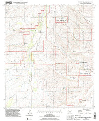
1996 Map of Spring Water Canyon
USGS Topo · Published 2002About this map
The cattle ranching heritage of Pima County is etched into this high-desert landscape, defined by the sprawling Las Cienegas National Conservation Area. Numerous family-named homesteads, including Cienega Ranch, Hummel Ranch, and Clyne Ranch, occupy the drainage basins where intermittent water sources were vital for survival. The reliance on subterranean water is evident through a dense network of specialized infrastructure such as the Diamond A Windmill, Cieneguita Windmill, and Lower Spring Water Windmill. Topographically, the area is a complex system of washes and canyons, with Cienega Creek and Spring Water Canyon serving as primary geographic markers. The presence of an Oil Well Tank and a remote Landing Strip further illustrates the varied industrial and logistical uses of this arid terrain in the late 20th century.
Find a feature on this map
39 named features on this map. Tap any name to fly to it.
Don’t see what you’re looking for? This feature index may not catch every label — zoom into the map to look around manually.
Map Details
Editions of this 1996 Spring Water Canyon Map
This is the sole edition of this map. No revisions or reprints were ever made.
Other maps of this area

1904 · Patagonia
USGS Topo · 1:125,000

1905 · Patagonia
USGS Topo · 1:125,000

1915 · Benson
USGS Topo · 1:125,000

1926 · Whetstone
USGS Topo · 1:62,500

1932 · Elgin
USGS Topo · 1:62,500

1938 · Huachuca
USGS Topo · 1:62,500

1940 · Elgin
USGS Topo · 1:62,500

1943 · Benson
USGS Topo · 1:125,000

1947 · Elgin
USGS Topo · 1:62,500

1948 · Elgin
USGS Topo · 1:24,000