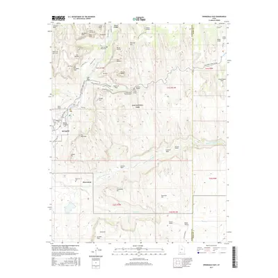
2017 Map of Springdale East
USGS Topo · Published 2017About this map
Springdale and the riverside settlement of Shunesburg anchor this topographical study, which reveals the dramatic vertical landscape of Zion National Park. The North Fork Virgin River and East Fork Virgin River carve deep routes through massive geological formations, providing the lifeblood for these canyon communities. This era of the landscape is defined by the sophisticated engineering of the Zion-Mount Carmel Highway Tunnel and the Zion-Mount Carmel Highway, which navigate the sheer sandstone walls. For genealogists and local historians, the map documents significant cultural sites including the Shunesburg Cem and Hilltop Cem. Landmark formations such as the Three Patriarchs, The Watchman, and the distinctive Checkerboard Mesa provide a detailed spatial context for the trails and roads, like the Pa'rus Trail, that link the canyon floor to its high rims.
Find a feature on this map
74 named features on this map. Tap any name to fly to it.
Don’t see what you’re looking for? This feature index may not catch every label — zoom into the map to look around manually.
Map Details
Editions of this 2017 Springdale East Map
This is the sole edition of this map. No revisions or reprints were ever made.
Other maps of this area

1885 · St. George
USGS Topo · 1:250,000

1886 · Kanab
USGS Topo · 1:250,000

1891 · St. George
USGS Topo · 1:250,000

1953 · Cedar City
USGS Topo · 1:250,000

1954 · La Verkin 4 SE
USGS Topo · 1:24,000

1954 · Orderville Canyon SE
USGS Topo · 1:24,000
1956 · Springdale SE
USGS Topo · 1:24,000
1956 · Springdale SW
USGS Topo · 1:24,000

1956 · Springdale NE
USGS Topo · 1:24,000

1958 · Cedar City
USGS Topo · 1:250,000