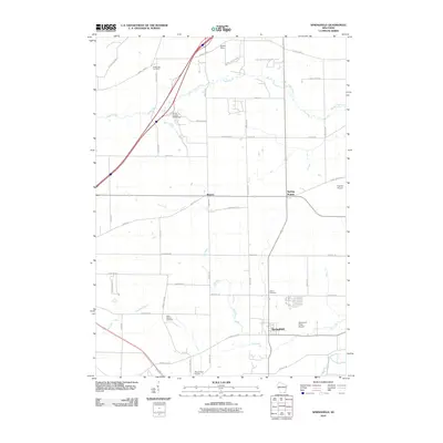
2010 Map of Springfield
USGS Topo · Published 2010About this map
The agrarian landscape of eastern Walworth County is defined here by the winding course of Sugar Creek and Ore Creek as they flow toward the White River. The settlement of Springfield sits at a crossroads in the south, while the small communities of Spring Prairie and Bowers anchor the central portion of the map. This 2010 survey illustrates the modernization of the region, where legacy agricultural lands exist alongside the Alpine Valley Resort and localized infrastructure like the Elmer Droster E5299 Dam. Genealogists will find significant value in the documentation of three distinct burial grounds: White Oak Cemetery in the north, Union Cemetery near Springfield, and North Geneva Cemetery to the southwest. The presence of several private airstrips, including Fletcher Airport and Plows and Props Airport, points to the unique aviation character of this rural Wisconsin corridor.
Find a feature on this map
46 named features on this map. Tap any name to fly to it.
Don’t see what you’re looking for? This feature index may not catch every label — zoom into the map to look around manually.
Map Details
Editions of this 2010 Springfield Map
This is the sole edition of this map. No revisions or reprints were ever made.
Other maps of this area

1892 · Whitewater
USGS Topo · 1:62,500

1892 · Eagle
USGS Topo · 1:62,500

1893 · Delavan
USGS Topo · 1:62,500

1893 · Whitewater
USGS Topo · 1:62,500

1893 · Geneva
USGS Topo · 1:62,500

1894 · Eagle
USGS Topo · 1:62,500

1897 · Eagle
USGS Topo · 1:62,500

1903 · Whitewater
USGS Topo · 1:62,500

1904 · Lake Geneva
USGS Topo · 1:62,500

1906 · Eagle
USGS Topo · 1:62,500