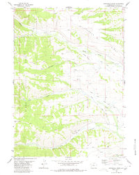
1980 Map of Springman Creek
USGS Topo · Published 1980About this map
The Emigrant Trail (Lander Cutoff) traces a historic westward path across this high-elevation landscape, where irrigation engineering meets high-country hydrology. Water management dominates the eastern slopes of Riley Ridge and Johnson Ridge, evidenced by an extensive network of named gravity-fed channels such as Finnegan Ditch, Barbara Budd Ditch, and Miami Ditch. These diversions draw from the headwaters of South Piney Creek and Fish Creek to support ranching operations in the valleys below.
Find a feature on this map
19 named features on this map. Tap any name to fly to it.
Don’t see what you’re looking for? This feature index may not catch every label — zoom into the map to look around manually.
Map Details
Editions of this 1980 Springman Creek Map
This is the sole edition of this map. No revisions or reprints were ever made.
Other maps of this area

1921 · Afton
USGS Topo · 1:125,000

1936 · Cokeville
USGS Topo · 1:96,000

1939 · Big Piney
USGS Topo · 1:125,000

1942 · Cokeville
USGS Topo · 1:125,000

1942 · Big Piney
USGS Topo · 1:125,000

1955 · Preston
USGS Topo · 1:250,000

1958 · Preston
USGS Topo · 1:250,000

1962 · Preston
USGS Topo · 1:250,000

1967 · Mount Thompson
USGS Topo · 1:24,000

1969 · Cretaceous Mountain
USGS Topo · 1:24,000