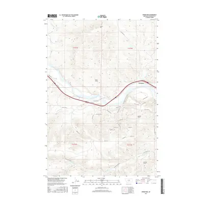
2017 Map of Springtime
USGS Topo · Published 2017About this map
The Yellowstone River cuts a wide, meandering path through this landscape, creating a natural divide between the northern uplands and the intricately drained coulees to the south. Near the settlement of Springtime, the river valley is a focal point for transportation, with major roads like the E Frontage Rd and Elkhorn Rd tracing its course. To the north, the terrain rises toward Warner Hill, while the southern half of the map is defined by a network of drainage features including Bridge Coulee, Haystack Coulee, and Kennedy Coulee. This 2017 survey reveals a modern rural environment where historic western travel is still evoked by names like the Old Cowboy Trl and Wild Horse Run. Local creeks such as Whistle Cr and Countryman Cr feed into the main river channel, supporting the ranching and agricultural life of Stillwater County.
Find a feature on this map
40 named features on this map. Tap any name to fly to it.
Don’t see what you’re looking for? This feature index may not catch every label — zoom into the map to look around manually.
Map Details
Editions of this 2017 Springtime Map
This is the sole edition of this map. No revisions or reprints were ever made.
Other maps of this area

1891 · Big Timber
USGS Topo · 1:125,000

1892 · Stillwater
USGS Topo · 1:125,000

1893 · Big Timber
USGS Topo · 1:125,000

1954 · Billings
USGS Topo · 1:250,000

1955 · Antelope Point
USGS Topo · 1:24,000

1955 · Sandborn Creek
USGS Topo · 1:24,000

1955 · Reed Point
USGS Topo · 1:24,000

1955 · Springtime
USGS Topo · 1:24,000

1955 · Whitebird School
USGS Topo · 1:24,000

1955 · Absarokee
USGS Topo · 1:24,000