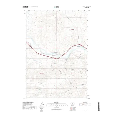
2020 Map of Springtime
USGS Topo · Published 2020About this map
The Yellowstone River cuts a wide path through this Stillwater County landscape, defining the corridor for transport and settlement. Along its northern banks, the small community of Springtime and the locality of Craver sit near the path of Old US Hwy 10, while the southern hills are marked by a network of evocative local tracks including Old Cowboy Trl and Wild Horse Run. The terrain is deeply incised by numerous seasonal drainages, most notably Bridge Coulee, Haystack Coulee, and Kennedy Coulee, which descend from high points like Jacobs Hill and Warner Hill. This modern survey illustrates how modern infrastructure like the Interstate and Twin Bridges Rd follows the same natural river breaks established by early travelers. The map provides clear detail for tracing land boundaries within t1s r18e and neighboring townships as the river winds through this high plains environment.
Find a feature on this map
40 named features on this map. Tap any name to fly to it.
Don’t see what you’re looking for? This feature index may not catch every label — zoom into the map to look around manually.
Map Details
Editions of this 2020 Springtime Map
This is the sole edition of this map. No revisions or reprints were ever made.
Other maps of this area

1891 · Big Timber
USGS Topo · 1:125,000

1892 · Stillwater
USGS Topo · 1:125,000

1893 · Big Timber
USGS Topo · 1:125,000

1954 · Billings
USGS Topo · 1:250,000

1955 · Antelope Point
USGS Topo · 1:24,000

1955 · Sandborn Creek
USGS Topo · 1:24,000

1955 · Reed Point
USGS Topo · 1:24,000

1955 · Springtime
USGS Topo · 1:24,000

1955 · Whitebird School
USGS Topo · 1:24,000

1955 · Absarokee
USGS Topo · 1:24,000