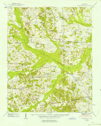
1938 Map of Springville
USGS Topo · Published 1963About this map
The Louisville and Nashville railroad cuts a diagonal path through this 1938 landscape, connecting the small settlements of Nobles and Springville. This rural portion of Henry County is defined by an intricate drainage system, with the Holly Fork and West Sandy Creek meandering through the bottomlands. The map reveals a high density of community institutions from the pre-war era, including the Sulphur Well Academy and local gathering places like Lebanon Ch and New Bethel Ch. The presence of numerous family cemeteries, such as Beaverdam Cem and Nichols Cem, provides a detailed record of the local genealogy. This period of the county's history shows the transition from traditional creek-side settlements to a landscape shaped by both rail transport and early drainage improvements like Chandler Ditch.
Find a feature on this map
63 named features on this map. Tap any name to fly to it.
Don’t see what you’re looking for? This feature index may not catch every label — zoom into the map to look around manually.
Map Details
Editions of this 1938 Springville Map
2 editions found
Other maps of this area

1936 · Poplar Creek
USGS Topo · 1:24,000

1936 · Conyersville
USGS Topo · 1:24,000

1936 · Buchanan
USGS Topo · 1:24,000

1936 · Big Sandy
USGS Topo · 1:24,000

1936 · Mansfield
USGS Topo · 1:24,000

1936 · Centerville Landing
USGS Topo · 1:24,000

1936 · Manleyville
USGS Topo · 1:24,000

1936 · Paris
USGS Topo · 1:24,000

1936 · Springville
USGS Topo · 1:24,000

1938 · Springville
USGS Topo · 1:24,000