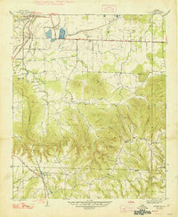
1947 Map of Spruce Pine
USGS Topo · Published 1977About this map
Russellville and the surrounding Franklin County uplands are defined by a complex landscape of industry and nature in the late 1940s. Heavy industrial activity is evident in the expansive Strip Mine operations flanking the Southern railroad line, while just to the south, the terrain shifts into the heavily wooded ridges of the William B Bankhead National Forest. This survey captures a rural community organized around small hubs like Newtown, Gravel Hill, and Waco, where local life centered on institutions such as Sloss Sch, Hurricane Sch, and Cedar Grove Ch.
Find a feature on this map
51 named features on this map. Tap any name to fly to it.
Don’t see what you’re looking for? This feature index may not catch every label — zoom into the map to look around manually.
Map Details
Editions of this 1947 Spruce Pine Map
2 editions found
Other maps of this area

1924 · Tuscumbia
USGS Topo · 1:48,000

1925 · Barton
USGS Topo · 1:62,500

1926 · Tuscumbia
USGS Topo · 1:62,500

1926 · Barton
USGS Topo · 1:48,000

1929 · Barton
USGS Topo · 1:62,500

1936 · Russellville
USGS Topo · 1:24,000

1936 · Newburg
USGS Topo · 1:24,000

1936 · Kinlock Spring
USGS Topo · 1:24,000

1936 · Frankfort
USGS Topo · 1:24,000

1936 · Isbell
USGS Topo · 1:24,000