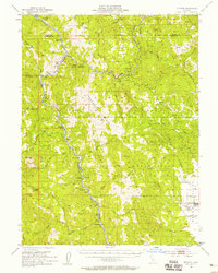
1952 Map of Spyrock
USGS Topo · Published 1958About this map
The Round Valley Indian Reservation dominates this 1950s landscape, centered on the fertile Round Valley and the settlement of Covelo. The terrain is defined by the deep canyons of the Eel River and its North Fork Eel River, where the Northwestern Pacific railroad follows the water's edge. This corridor supported a string of small riverside communities and stops, including Spyrock, River Garden, Nashmead, and Woodman. Higher into the surrounding mountains, remote outposts like Mina and Bell Springs overlook the drainage basins, while landmarks like Iron Peak Lookout provided essential fire watch for the timber-heavy region. The map reveals the intricate network of ranching and early mountain roads, such as Spyrock Road, which connected these isolated settlements before modern highway infrastructure reshaped travel through Mendocino and Trinity counties.
Find a feature on this map
49 named features on this map. Tap any name to fly to it.
Don’t see what you’re looking for? This feature index may not catch every label — zoom into the map to look around manually.
Map Details
Editions of this 1952 Spyrock Map
4 editions found

Other maps of this area

1920 · Cummings
USGS Topo · 1:62,500

1920 · Covelo
USGS Topo · 1:62,500

1920 · Harris
USGS Topo · 1:62,500

1921 · Branscomb
USGS Topo · 1:62,500

1921 · Hoaglin
USGS Topo · 1:62,500

1922 · Island Mountain
USGS Topo · 1:62,500

1926 · Covelo
USGS Topo · 1:62,500

1929 · Eden Valley
USGS Topo · 1:62,500

1931 · Hoaglin
USGS Topo · 1:96,000

1935 · Hoaglin
USGS Topo · 1:125,000