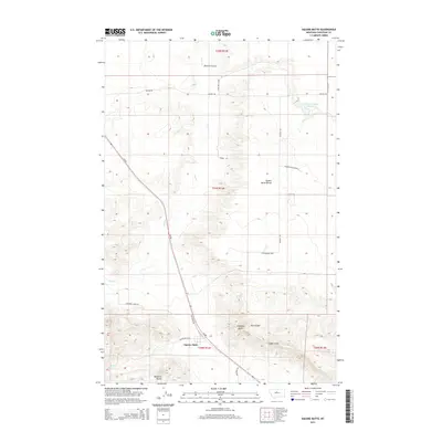
2014 Map of Square Butte
USGS Topo · Published 2014About this map
Square Butte stands as a prominent landmark in this section of Chouteau County, where the landscape is defined by the sharp verticality of the Chalk Cliffs and the broad expanses of the Square Butte Bench. The settlement at Square Butte is the central hub of a rural network connected by MT-80 and local routes like Lonetree Stage Rd. The topography is etched by drainage systems including Panton Coulee, Flat Cr, and Cowboy Cr, reflecting a region where water management is critical for agriculture and ranching, as evidenced by the Panton Coulee Reservoir. Further south, Buckskin Butte and Antelope Butte rise from the plains near Big Coulee, illustrating the transition from flat benchlands to the dramatic formations that characterize this part of Montana.
Find a feature on this map
27 named features on this map. Tap any name to fly to it.
Don’t see what you’re looking for? This feature index may not catch every label — zoom into the map to look around manually.
Map Details
Editions of this 2014 Square Butte Map
This is the sole edition of this map. No revisions or reprints were ever made.
Other maps of this area

1890 · Fort Benton
USGS Topo · 1:250,000

1892 · Fort Benton
USGS Topo · 1:250,000

1897 · Fort Benton
USGS Topo · 1:250,000

1954 · Great Falls
USGS Topo · 1:250,000

1957 · Great Falls
USGS Topo · 1:250,000

1972 · Square Butte SE
USGS Topo · 1:24,000

1972 · Square Butte
USGS Topo · 1:24,000
1972 · Dammel Reservoir
USGS Topo · 1:24,000
1972 · Square Butte NE
USGS Topo · 1:24,000
1972 · Geraldine NE
USGS Topo · 1:24,000