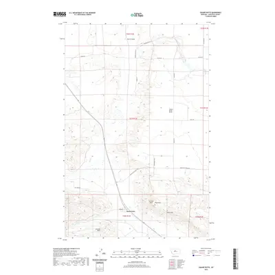
2020 Map of Square Butte
USGS Topo · Published 2020About this map
Square Butte stands as the primary settlement in this section of Chouteau County, where the plains of Central Montana meet dramatic geological formations. The landscape is defined by its topographic extremes, from the high, flat expanses of Square Butte Bench to the deeply incised drainage of Big Coulee and the striking Chalk Cliffs. The area’s hydrology is dominated by the seasonal paths of Flat Cr and Cowboy Cr, which carve through the coulees and benchlands. Transport and local access follow the section lines and terrain contours, with routes like Square Butte Bench Rd and Broadway serving the scattered ranching interests. The presence of multiple distinct peaks, including Buckskin Butte and Antelope Butte, highlights the isolated high points that characterize this region north of the Highwood Mountains.
Find a feature on this map
24 named features on this map. Tap any name to fly to it.
Don’t see what you’re looking for? This feature index may not catch every label — zoom into the map to look around manually.
Map Details
Editions of this 2020 Square Butte Map
This is the sole edition of this map. No revisions or reprints were ever made.
Other maps of this area

1890 · Fort Benton
USGS Topo · 1:250,000

1892 · Fort Benton
USGS Topo · 1:250,000

1897 · Fort Benton
USGS Topo · 1:250,000

1954 · Great Falls
USGS Topo · 1:250,000

1957 · Great Falls
USGS Topo · 1:250,000

1972 · Square Butte SE
USGS Topo · 1:24,000

1972 · Square Butte
USGS Topo · 1:24,000
1972 · Dammel Reservoir
USGS Topo · 1:24,000
1972 · Square Butte NE
USGS Topo · 1:24,000
1972 · Geraldine NE
USGS Topo · 1:24,000