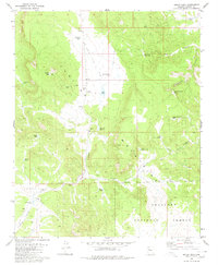
1980 Map of Squaw Peak
USGS Topo · Published 1980About this map
The Juniper Mountains dominate this high-desert landscape in Yavapai County, where water management is the primary marker of human activity and ranching history. A network of stock tanks, such as Little Phil Tank, Gosney Tank, and the descriptive Broken Dam Tank, illustrates the necessary infrastructure for cattle operations like the H-Ranch. The prominent Squaw Peak rises in the western portion of the sheet, topped by a radio tower, while the southern reaches fall within the boundary of the Prescott National Forest. Natural water sources like Green Waterhole Spring and the ephemeral Red Lake suggest a reliance on seasonal hydrology. This 1980 edition provides a record of the region's topography and land use just prior to more modern shifts in forest management, preserving the location of specific borrow pits and remote cattle-watering sites across the Lion and Purcell drainage systems.
Find a feature on this map
28 named features on this map. Tap any name to fly to it.
Don’t see what you’re looking for? This feature index may not catch every label — zoom into the map to look around manually.
Map Details
Editions of this 1980 Squaw Peak Map
2 editions found
Other maps of this area

1886 · Diamond Creek
USGS Topo · 1:250,000

1886 · Chino
USGS Topo · 1:250,000

1891 · Chino
USGS Topo · 1:250,000

1892 · Diamond Creek
USGS Topo · 1:250,000

1947 · Turkey Canyon
USGS Topo · 1:62,500

1948 · Williams
USGS Topo · 1:250,000

1950 · Turkey Canyon
USGS Topo · 1:62,500

1954 · Williams
USGS Topo · 1:250,000

1956 · Williams
USGS Topo · 1:250,000

1960 · Williams
USGS Topo · 1:250,000