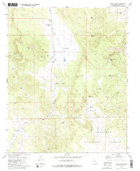
1980 Map of Squaw Peak
USGS Topo · Published 1980About this map
The Juniper Mountains dominate this landscape, where high-altitude water management is central to the area's utility. At the heart of the terrain lies Red Lake Flat, a broad basin containing Red Lake and a series of livestock tanks like Red Lake Tank and Jolly Place Tank. This 1980 survey captures the grazing infrastructure of the era, marked by features such as the H-Ranch and numerous Borrow Pits that suggest road maintenance and local earthmoving. The eastern slopes are carved by steep drainages, including Grapevine Canyon and Purcell Canyon, which descend toward the lower basins. Much of the southern portion is protected within the Prescott National Forest, while the namesake Squaw Peak stands as a prominent high point, capped by a Radio Tower. The distribution of scattered springs like Green Waterhole Spring highlights the critical importance of water sources in this arid Yavapai County upland.
Find a feature on this map
30 named features on this map. Tap any name to fly to it.
Don’t see what you’re looking for? This feature index may not catch every label — zoom into the map to look around manually.
Map Details
Editions of this 1980 Squaw Peak Map
2 editions found
Other maps of this area

1886 · Diamond Creek
USGS Topo · 1:250,000

1886 · Chino
USGS Topo · 1:250,000

1891 · Chino
USGS Topo · 1:250,000

1892 · Diamond Creek
USGS Topo · 1:250,000

1947 · Turkey Canyon
USGS Topo · 1:62,500

1948 · Williams
USGS Topo · 1:250,000

1950 · Turkey Canyon
USGS Topo · 1:62,500

1954 · Williams
USGS Topo · 1:250,000

1956 · Williams
USGS Topo · 1:250,000

1960 · Williams
USGS Topo · 1:250,000